Tuesday, September 17, 2013

Springville Museum of Art

Directions: Off of I-15 take Springville 400 N Exit and go east almost 2 miles. It is just after the stoplight in town. There is parking on the street and on the East side of the building (which is where the entryway is)
Cost: Free -
                   Donations Always Appreciated!
Museum from the Road


Outside entrance to the sculpture garden - a truly wonderful place!

Duration: As long as you like!

This activity/ place is great for art lovers, date night, people who are curious about Utah places and children.


This museum has permanent art as well as traveling exhibits. They quite often feature quilting and the amazing quilting art that is done by so many talented artists/ seamstresses. (fyi.. if you haven't tried to make a quilt you will not fully appreciate the technical aspects of quilting- it is amazingly precise, tedious, artistic, mathematical and artistic in every sense! as well as demanding immense patience)
A sculpture, some flowers and the walkway by the Museum.. its just a pretty area. The flowers are just part of the beautiful garden.. I guess you could consider them a permanent part of the exhibit.. and I just really like taking pictures of flowers.

This makes a wonderful outing, tandem picnic or brunch outing or just a relaxing personal time in the sculpture garden by the fountain (there is an indoor water feature too).

Don't go on Monday.. they are closed. (that is why all my pictures are from the outside)

Hours: ( in case you can't read it)
Monday  closed
Tuesday 10am-5pm
Wedensday 10am-9pm
Thursday-Saturday 10am-5pm
Sunday 3pm-6pm

If you are interested in taking professional (or family member/friend professional pictures.. there is a small fee (a small cost to enjoy the beautiful backdrop) and you may photograph within the building or the gardens.

check out their website for more information at:
http://www.smofa.org/visit_the_museum/hours/index.html

Sunday, September 15, 2013

Bridal Veil Falls American Fork Canyon and Provo River Trail

Directions: Just off of Highway 189 out of Provo and just before Deer Creek. A pull off is located at Nunn's Park, but if you want to bike on a beautiful trail you can access it at the Provo Canyon Bike trailhead and can get on at the gas station just off of 800 N just before turning onto 189, at Canyon View Park or Canyon Glenn Park.  This paved trail is for bikes, roller blades, scooters, big wheels, tyke bikes, pedestrians, dogs and strollers. If you just want to do the lazy walk (like we did today) you can drive pretty much right up to the falls and park just across the Provo River.
from the parking area

Difficulty: Pretty flat and easy to get to, good for all ages. If you access through the bike trails, also not too hard as manifested by the little guy with gusto on the big wheel who rode up from one of the parks.

Duration: However long you want it to be. You can make your trip as long as the hike and full bike path ride (going from down in Provo even as far down at the River bottoms all the way up to Vivian Park) or as short as parking across from the falls and walking over the little bridge to the viewing area.
There is also an unpaved trail further up the canyon where you can hike up to where the fall splits.
from the biking/hiking trail
The falls is 607 Feel and is made up of two falls that tumble down into a rocky area and then a small pool where there is a trout pond and then on to join the Provo River.
For a quarter you can feed the fat trout but you can't eat them.

Its a lovely and relaxing visit and a wonderful beautiful trail to ride.
This is a great family outing and good for the dog too if you want. Just make sure to clean up after your pet as this is a high traffic area and no one wants the remains of what your dog left of the trail to be on the bottom of their shoe.

Monday, August 19, 2013

Cascade Springs

Approaching the upper Springs from below

Directions:  Alpine Scenic Loop up American Fork canyon ( or you can come up from Provo Canyon), take the Cascade Spring turn off, If you have not been on the Alpine loop be forewarned that it is veryt narrow in some places, while a great motorcycle ride sometimes you may be cut off by trucks, cars or vehicles with trailers (which over 30 feet - not recommended)
this road is a popular scenic road /Sunday drive type road that is especially popular in the fall. If you or others in your car are prone to motion sickness, you may want to prepare for the possibility of someone getting sick as it is also very a very winding road.
There is an upper and lower parking lot.
Cost: National Parks pass or current fee ($6.00 per Sept of 2013)

waterfalls in the lower Spring area

Difficulty: Easy, Wheel chair accessible ( for the most part flat and a bit steep in a few places).
Mostly paved or boardwalk. (some of the asphalt is a little broken up by some trees and it is narrow in some places. There are some rock stairs - which are beautiful.
Overall this is a wonderful hike for people of all ages and abilities.

Duration:  .6 miles, minimal elevation
Stay however long you want as you can be as hurried or leisurely as you want.
If you park at the upper parking lot you will come in on the wide open end at the top of the spring.  This part is very serene and relaxing.
If you come up from the bottom parking lot the terrain is a little more uneven and the falls are spectacular and make a wonderful gurgling, rushing sound.
The whole trail is marked with educational plaques so you can learn much of the area, flora, fauna and wildlife, history, geology and other interesting information.
You will be able to see the brown trout in the clear waters and maybe some mink, birds, squirrels or other little critters. There are abundant flowers and plants of all kinds.
Sunday afternoon visitors early fall on the Boardwalk


Tips: This is a good one to do in conjunction with some other Alpine Loop trail or if you are in the area, camping or ATV'ing since its such a short hike to just drive up for that alone.  It is a beautiful  little hike and well worth it to go in and of itself.
Its a very relaxing place and nice to take pictures.
Bridal Veil Falls is on the way if you are coming up from or going back through the Provo area.
lower Springs area looking up through some trees

Bug spray would be advisable and the park closes at dusk!
No picknicking in the area, no fishing and no wading allowed.
This is a very beautiful area as noted by the numerous photographers we saw there, but you can enjoy it for its relaxing nature, beauty and pure water.
Drinking fountains available with delicious water!
delicious spring water (pretty sure about that)

If you want to take a longer scenic drive you can continue to head East, up and over into Heber Valley, visiting Midway on the way home or go back the way you came enjoying the Alpine Loop.


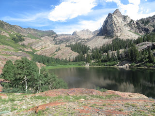
Cecret Lake (Secret Lake)

Directions: Top of Alta / Little Cottonwood Canyon, parking by the Albion Basin Campground.

Difficulty: Easy, dirt and rock path up to a mountain lake. No swimming, pets or fishing. 1.2 miles, 450 elevation. While its pretty simple, well maintained trail, it is challenging enough to give you a basic workout and make the kids feel like they got a really good mountain hiking adventure.

Durations: from parking lot to parking lot - about 1 1/2 hour, with a stop at the top for snacks and pix. if you go on a weekend or holiday you may have to park a little further out and walk up the campground where the trail head starts by a little footbridge.

Tips: Good picnic place, good family hike, awesome in mid to late summer, may still be some snow and lots of beautiful mountain wildflowers. Beautiful also in the fall, be prepared for really cool temperatures up in the higher elevations, be prepared with layers, sunscreen, water, treats - depending on the time of year.

What may look like a terrible day in the valley could possibly be an awesome day in the mountains....
likewise ...
what looks like a great day in the valley might be kind of dangerous weather up in the higher elevations. Check weather before heading out and be prepared with appropriate clothing and supplies... even for short hikes.


Pictures coming later this week !

Tuesday, August 13, 2013

Huntington Lake, Miller Flat and Joe's Valley

Miller Flat Lake  // waterful nearby.... Skyline Drive Trail - late June

Mountain flowers with small spider... a trail with summer flowers... liatris flowers


Directions: Fairview 16 miles East on UT 31, South on Miller Flat Road, park anyhwere or pick a campsite and stay a couple days. Campsites are open, roomy and plentiful. There are ample places and trail to ride bikes, ATV's, fish and hike. The whole area is very beautiful. 
Distance: trail -  as long or short as you want them to be. Hooks into Skyline Drive trail.
Fishing available in several lakes
Difficulty: pretty normal
High Altitudes in even late june can be cold (see the snow on the upper picture - if out on an ATV plan to have appropriate clothing (windbreaker, fleece, wool, coat, gloves, hat would be good)
lower elevations are warm so layering is good. 
If you like flowers and trees, bring a book to identify them - they are plentiful as are small lakes and ponds throughout.

Saturday, July 20, 2013

Stewart Falls - American Fork Canyon

Directions:Trailhead is up American Fork Canyon Alpine Loop road by the Mt. Timpanogos trail head. there are several trails so follow the signs
Duration: 1.5hr -2  hours
Distance: 4 miles out and back
Difficulty: Easy/Medium - June thru October
This is a fun and easy day hike and the falls is refreshing to sit by and very beautiful.
Makes a great picnic day hike.


link: http://www.utah.com/provo/hiking_trails.htm

Lake Blanche, Lily and Florence and Sundial Peak - Big Cottonwood Canyon


Directions: park at the S curve on the road up Big Cottonwood Canyon/trailhead is here (about 4.5 miles up the canyon)

Duration: 2.5 hours - or about 3 if hiking with smaller hikers - or if you are really sick thinking you have allergies and don't want to admit it that you are - really sick -  and  have to stop a lot.
Distance: about 2 3/4
Difficulty: Medium if you are in reasonably good shape.

It is mostly uphill with a little climbing over rocks toward the top. Lots of people had hiking sticks and it would be a good idea if you have knee issues as there is a lot of uphill on the way up and amazingly enough.. lots of downhill on the way down.

Tips: we took lots of water and drank it all. It was July and freakishly hot...even in the mountains (aorund 100 the day we did the hike) We took a water purifier and were really glad to have it. Take a nice picnic, its a beautiful place to lunch.
While going up I thought... I will never do this again. But after seeing how amazingly beautiful it was ...I probably will. Just not when I am sick!
Definitely want to bring your camera. Bug spray is a good idea since there are some mosquitoes just before the lake (don't remember being bugged by any while at the lake though. Lots of flies during the summer - which was a blessing (kept us moving) and a curse (annoying).
The extra distance to Lake Lilly and Florence just beyond was well woth it and even though you are probably going to be tired, take a breather and press on. Sundial peak is wonderfully beautiful, the other lakes are also amazing, peaceful and picturesque. there is a great waterfall between Blanche and Lilly and lots of places to relax and enjoy the day.
When I do it again I am going earlier in the day and spend a little more time up there.


Day Hike - Donut Falls - Big Cottonwood Canyon

This is a fun, fairly easy hike that many families do as a tradition. It doesn’t take too long and it’s pretty amazing without too much effort.
stinging nettles - don't touch! /yarrow - good for cuts / sticky geranium / wild carrot


Distance: ¾ mile
Duration: about 30 minutes
Difficulty: easy/medium – there were people with babies in packs, small children and lots of grandparents there with their grandkids. Some climbing involved in a couple of places and some elevation at the beginning of the trail, but otherwise fairly flat.
Climbing to the falls may be tricky as the rocks or dirt areas are often slippery and can also be unstable but most people climb up and go in to view the falls as it comes through the “donut”.
Directions: about 9 miles from the bottom of Big Cottonwood Canyon turn off at Jordan Pines and follow the road up past the private property signs to the parking lot trailhead
along the trail/ your feet will get wet... these were the perfect shoes!/ some pretty plants by the falls/ going straight up

on the bridge/good shoes-plan to get wet or go barefoot/the mouth of the falls cave/ inside

view from the top/the top of the falls/ looking down/ pretty but don't eat - black twinberry

Tips: A picnic is popular. There are some flies (deer flies and horse flies but while annoying they aren't too bad). The trail has lots of wildflowers but also stinging nettle (see above picture for identification if you don't know what it is- tall skinny plant with serrated knife shaped leaves and white tassel flowers) next to some parts of the trail so watch out for it and make sure your kids don’t touch it.


Friday, June 21, 2013

Katherine Pass Day Hike


Place:  Little Cottonwood Canyon – end of the canyon by Albion Basin Campground
Location: there is a trail head by a ski lift as you go to the top of Little Cottonwood canyon, past the booth and up a dirt road (not open until July 4th so if you go early.. less hikers but you will have to walk further)
What to do: Hiking, nature, flowers, picnic
Time of Year: mid spring to fall
Fees: no
Camping:   Albion  Campground is nearby and very nice. You will probably see moose!
Picnic area: yes – anywhere along the way.. favorite resting/picnicking spots – top of Katherine or by Mary or  Martha   Lakes

We hiked to the top from the paved parking lot and it took us 4 hours up and back. We are in pretty good shape but we did stop a lot... first big hike of the year
If you plan on hiking up and going to the lakes (good fishing if you have a license) it will be pretty much all day.
I have done this with Grandpa and little kids and everyone can do it.. it may take longer.
Don't forget water and snacks, sunscreen and hats. Hiking sticks are a good idea and a camera is a must!
pictures from the trail and a tiny White Crested Sparrow nest on the ground! bonus!

If you park a car at Brighton you can hike all the way over.. then you have to go back and get the car but its a nice hike. It will take all day
early spring flowers


Legacy Highway and Jordan River Bike Trail

Place: Along the Jordan River and Legacy Highway
Location: here is a great link with map and directions - you can get on in many places and go as long or little as you like
here is a link for the Jordan river portion. They are connected.
I like the Legacy portion as you don't have to cross any roads and can ride uninterrupted for longer. The trail is mostly flat and paved although there are some dirt parts. It is along suburban and rural areas and very beautiful. Many parts are by the river and shaded by trees.

What to do:  Get on your bike and ride!
Don't forget water, snacks, helmet and sunscreen!
Lots of people also jog, walk and rollerblade.
Time of Year: any time there is no snow - unless you want to walk it in the snow
Fees: none
Camping:  - no

Picnic area: yes - there are parks and stops along the way

Annual Little Red Bike Race


Place: Logan Utah – or thereabouts
Location: different start areas but generally in the area of Logan and all around and back
What to do: This is a Ladies only bike ride – register early to get in (February)
It is a wonderful, fun, well supported race that will accommodate any level of ability and fitness. Everyone is welcome to enter and proceeds benefit Breast Cancer.
It usually has a fun theme – like this year was Bollywood with decorations, Indian Food, bollywood themed music and dancing and some fun Jersey ’s.
Time of Year: usually last weekend in May/first week June
Fees: yes – to participate (goes to a great cause) none if you are just volunteering or supporting.
Camping:  yes, there is usually a field to park in or tent in.
Picnic area: yes

Chalk Art Day Downtown SLC! Second Week in June

Chalk Art Festival – Gateway
Sponsored by Utah Foster Care
Place: Gateway Shopping Center - Salt Lake City
Location: downtown Salt Lake Gateway – west of the main downtown area
What to do: Walk around and check out some amazing chalk pictures done by Utah and other chalk artists, check out shops and booths, music, play in the fountains, grab a bite to eat at the many wonderful restaurants and food places in the shopping center, watch people and generally have fun.
Time of Year: second weekend (Friday and Saturday) in June
Check their official website for the dates to register to volunteer, participate or just go wander around and have fun
Fees: yes – to participate (goes to a great cause) none if you are just visiting
Camping:  - not really .. there are camping areas near Salt Lake but this is a day activity
Picnic area: yes

This is a great fun family activity or date.
Its all done for 2013 but look for it in June of 2014!

Chalk Art Festival Downtown Salt Lake June 13 and 14, 2014! See you there!

Wednesday, May 1, 2013

Kanosh Utah - Adelaide Campground


Place: Kanosh, Utah

Location:  Adelaide campground Kanosh exit 146 off of I-15, From Kanosh go 5 miles east on Forest Road 106
What to do: Camping, Hiking, Biking, Relaxing, horse back riding, fishing, wildlife viewing, plein air painting
Time of Year: spring thru fall
Fees: yes
Picnic area: yes


You can camp in open areas off the road back beyond the camp or at the campground (no horses in the campground)


Connects to the Paiute ATV trails so if you have ATV’s – it’s a great adventure!

The Elms are beautiful. The Campground is picturesque, quiet and relaxing.
This is a great place for a family get together. We love memorial day camping here. Bring the guitars for the singalong at the fire!
Apparently there is a hot spring close by too.. meadow hot spring

Monday, April 8, 2013


Place: Rail Trail or Union Pacific Rail Trail
Location:  Just East of Salt Lake City, you can get on anywhere from Park City to Echo Lake

See map:   best map and tons of other Park City biking trails:
What to do:  Bike Ride – level of difficulty – easy/medium depending on how long you make it.
Time of Year: spring thru fall
Fees: none
Camping: echo lake
Picnic area: there are places to stop along the way and a picnic table here or there. You can start at Park City or  Wanship, or just off I-80 past Park City  and head to Echo, eat there and ride back makes a great ride.

Great Link with directions and information:
another great resource:


Caveats:  Bring water and sunscreen and whatever else you will need along the way (first aid kit is good.. see story below).
This is a great family ride as you can make it as long or easy as you can handle. The trail is wide and meandering through beautiful country scenery flanked by the mountains and hills on both sides as it follows I-80 from Park City to Echo.  There is very little elevation and what there is is very gradual. There may be some wind on the long Park City stretch before you go under the overpass and onto the main part of the trail.
You can see some wildlife (fox, birds, woodchuck, deer and more), beautiful scenery, trees, flowers and enjoy a wonderful day. 


     We have done this ride several times as a family and with me and some of my girls and friends.
The first time we did it we got a late start from the I-80 stop. We hadn't gone too far when my youngest daughter, trying to keep up with the older ones, crashed on a loose gravelly place and got some pretty good cuts on her elbow, arm and leg. She cried a bit, left some blood on the trail (its not there anymore), probalby could have used some stitches but she didn't want to quit, we patched her up, tied a bandana around her elbow and she rode the rest of the way to Echo Lake, and back in the dark! We arrived at Echo to watch the sunset and then headed back in the dusk. My husband used his cell phone as a light in the tunnel (it was ultimately dark and pretty scary) we nearly hit a waddling woodchuck in the dark and walked behind it until it got off the trail. It was quite an adventure and amazingly beautiful as the full moon bathed us in silvery light as it rose above the rocks. We got back to our truck around midnight. It was quite a memorable and fun trip.
     The next time was a girls only trip and we started at Wanship, went back to the gate and then on to Echo Lake. It was early in the day and we had a wonderful ride. We ate at a burger place in Echo and then rode back the short flat scenic distance to our car.

Friday, April 5, 2013

Little Sahara Sand Dunes


Place: Little Sahara Sand Dunes
Location: 115 miles southwest of Salt Lake, about an hour and a half or a little more
What to do: ATV, hiking, wildlife, digging in the sand, picnic, campfires, meditating, sledding, snowshoeing, photography, family parties
Time of Year: all year
Fees: yes
Camping: yes
Picnic area: yes


We have enjoyed Little Sahara during all seasons for all of the above mentioned activities.  It is a good place to go and have a lot of fun.
Not a lot of services there so make sure you bring what you need as far as food and water, gas and equipment. Camping is great. If you stay late you will see some night wildlife such as fox and owl.
Some areas have more ATV crowd and some are a little quieter. It’s a big place so I am sure if you are out to climb sand mountain or sit quietly and read you will find what you need.

handy link:  http://www.duneguide.com/sand_dune_guide_little_sahara.htm

One time we were here riding, hiking and playing as a family. Around dusk a couple of foxes started to hang around. My son went out and sat quietly and they came really close to him.They were pretty used to people but they would only come close to him. We called him "the fox whisperer".


Arches National Park


Place: Arches National Park
Location:
Just outside of Moab Highway 191 North
from Salt Lake City about  230 miles - about 4 hours
What to do: Hiking, Photography, People watching, Relaxing, Wildlife,
Time of Year: all year although it gets hot in the summer so hiking is better in the early hours
Fees: National Park fee (we’ve found a year pass is a good investment if you like hiking and camping)
Camping: yes – in the Park and in surrounding areas are great. Reservations recommended.
Most popular hikes:
Delicate Arch – medium level hike. Bring water, maybe snacks and sunscreen or a hat, but pretty much everyone can, and does, do it.
Great Photo Op!
Devils Garden Loop – has an easy and a longer loop. Take water and snacks and sunscreen or a hat.


My favorites:
 Fiery Furnace – not for the faint of heart – you need to register and take a mini “class” in order to get a permit to go in.  It is amazing, but it is like a maze, you may wander around so pay attention to where you are going, and going to come out.
Devils Garden: Filled with many beautiful arches and you can make the hike as long or short as you want.  Lots of side trails that you can see. Would be amazing to view some of the arches at sunrise!
Devils Garden:           http://climb-utah.com/Moab/devil.htm

Caveats: It’s a desert so it can be really cold and really hot. Sometimes its windy, which means your eyes and food will be full of sand. Also, the sun is intense, cover up and bring sunscreen! Stay on the trails, its easy to get lost!